|
N. Ireland is in the midst of a wild fire outbreak the likes of which we haven't seen in years. Barely a day goes by before another fire starts with news coverage on social media and main stream television, fire fighters just confirmed more than 350 wild fires within a week and with the good weather lasting another couple of days more fires were likely. News statements all stated that many of these fires were deliberate by either arsonists or land owners. Two days earlier on May 8th I was filming a major fire near Ballgawley in Co. Tyrone, it was the largest fire I had filmed since the Glenshane Pass gorse fires of 2018, in fact, the Ballygawley fire was longer and wider making the latter event the largest I had ever filmed with a drone. Once I posted footage and images online I was inundated with media interest from newspapers with the BBC and UTV licensing my content. These fires were big news and the footage provided rather dramatic views of the full blaze which helped with their own ground footage at the site in conjunction with reporters. While all this was going on I thought I would never see a gorse fire that large again for a long time.
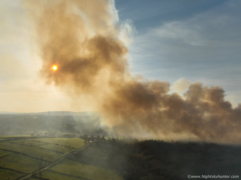
April 10th was once again an amazing day of unbroken sunshine, warm temperatures and clear skies, it really did feel like Summer had arrived early. I was on alert for more fires during the day however I wasn't expecting anything noteworthy after Ballygawley. By late afternoon/early evening I was walking my dog in Cookstown when I noticed signs in the sky. Most people don't pay much attention to the sky at the best of times especially, as in this case, if it was just a few random puffy cumulus clouds in an otherwise clear sky, what would be so interesting about that?, if you are a person who knows the sky these subtle signs can tell you something about the atmosphere.
There was a very subtle transparent strip of brown haze to the NW accompanied by a small cluster of five little cumulus puffs, everywhere else was blue skies. My first thought was those looked like pyrocumulus, these are clouds which can form above wild fires when rising heat condenses into clouds, they are very localized and form directly above the fire and often can be seen in proximity to the smoke plumes. Immediately I thought there was a fire to the NW of Cookstown however my view was restricted by trees and houses and I didn't see any tall smoke, maybe my senses had been over-heightened from filming these fires over the last few days, I told myself it was likely just a slight increase in moisture in the atmosphere ahead of a front slowly nudging in which would bring an end to the dry spell in the near future.
I went inside and checked online, it was then that I saw images online posted by two people I know showing smoke rising from a region of the countryside above Lough Fea. It was impossible to tell if this was a big fire or a small one someone started in their field but the location completely confirmed that what I had seen was indeed pyrocumulus, the instincts were good, there was a wild fire in progress and this one looked young as the reports where only posted within ten minutes. I didn't know exactly where it was but one of the posters told me to drive to Lough Fea and I would see it from there so I grabbed the gear, along with my dog Rhua, and we began driving towards the Lough. It was a gorgeous evening so my intentions were to have a look at this small fire using the drone then hang around for sunset. I couldn't see anything at all on the drive up, then I glimpsed smoke above a hill but the view was obscured, I turned off onto a back road which I thought would take me to that area but I messed up as the road backed around on itself taking me back to the main road, I was chasing my tail and had wasted valuable minutes, then I got back on track, reached the lough, then drove uphill near the scenic route and there was the fire in the distance. I pulled into a layby near an old abandoned quarry and Rhua and I ran across some boulders then onto a grassy hill which offered perfect line of sight.
 |
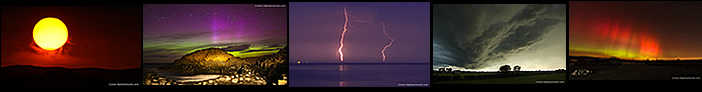
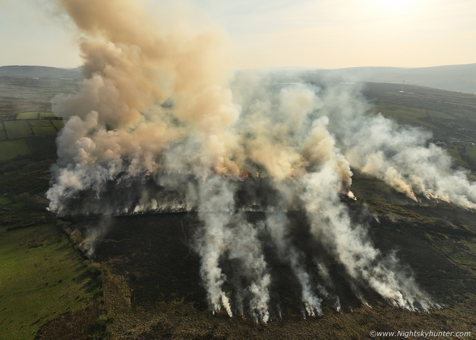
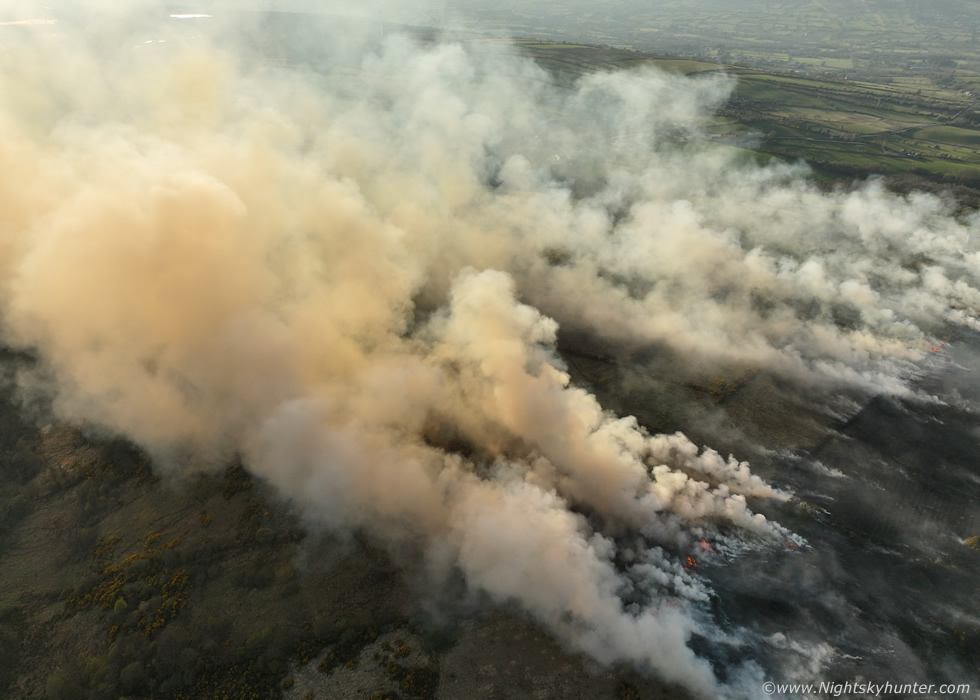
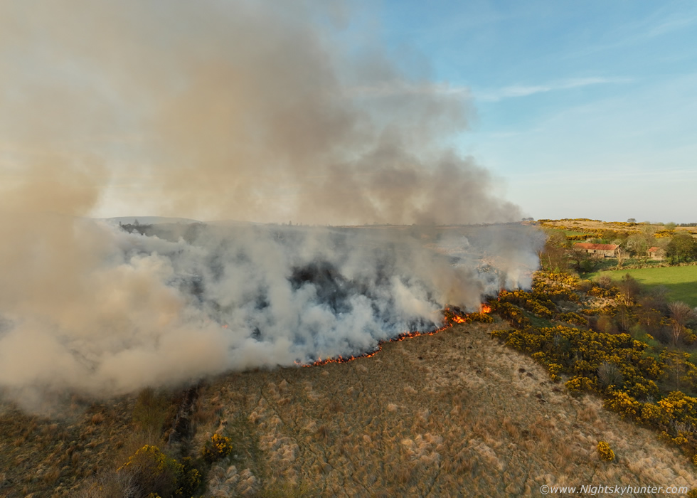
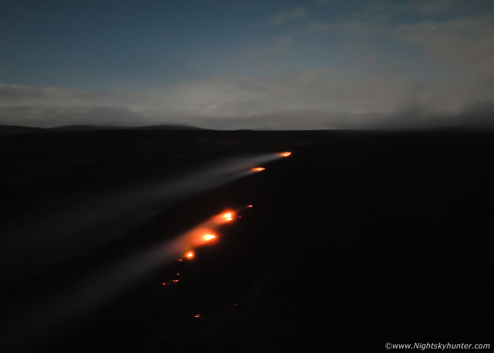
The fire was a fair distance away despite me being in the correct area, I didn't want to drive much closer in case I got in the way of any fire crews in attendance but once I settled in and got a good look by eye I was certain this was actually a very substantial fire and it even seemed to be growing by the minute. Several orange-brown and blue-white smoke plumes began to tower upwards and blow in my general direction. I began flying the drone towards the smoke, I couldn't escape the thought that this countryside was beautiful, rich in wildness and diversity and contrasting vibrant colours and a couple of hours before sunset it seemed to take on a gorgeous warm glow all of its own. The source of the fire was further away than I estimated by eye and it looked to be coming from a valley, this was looking much more substantial than I had originally thought. I was filming segments of video while stopping to hover and take still images, from the above image you wouldn't think anything significant was happening here but making assumptions about fires based on one angle can be very misleading.
 |
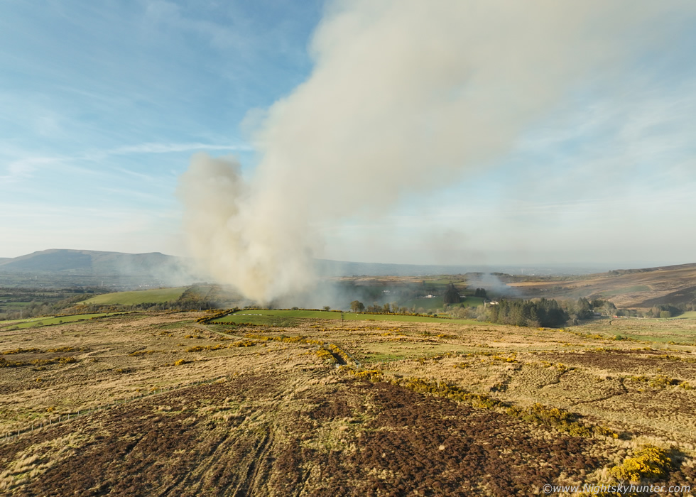
The drone was flying low, it cleared a small ridge, then the valley below came into view and I could see the full fire. My first thought was this reminded me of a wedge tornado made from smoke. I was shocked by the breeze, earlier it had been dead calm and the models never showed anything of note for today either, but now a strong breeze was blowing through my t-shirt and starting to chill me despite the warm evening air. This breeze was no doubt fueling this fire and judging by the wind direction the fire would be gradually moving towards that farm and house visible to the lower left. These kind of fires can vary drastically in appearance depending on your viewing angle, I like to think of them as similar to thunderstorm convection with the convection being the rising smoke towers.
If you are dealing with a strongly shear thunderstorm such a multicell or supercell the stronger winds aloft will blow cloud and precipitation downwind. If you are positioned downwind of the storm, which is the worst place to be for structure in most cases, then all you will see is a sky full of cloud obscuring anything of interest and eventually your view will be obscured by rain. If you want to see storm structure then you need to get to the side or rear of the storm. This example applies the exact same to wild fires and it was happening at this moment in time as the drone was approaching the front of the smoke from downwind, this meant I was not seeing the full extent of the fire and it could be much bigger than it even looked here. However the great thing about using a drone is that you can move it into any position you want and you are entirely unrestricted by roads and terrain so I began slowing flying the drone around the right side of the smoke.
 |
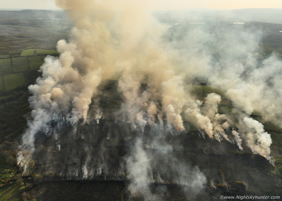
The drone was leaving the downwind smoke and approaching the side of the fire when I began to get a better understanding of the scale. In the background I heard sirens from more fire engines arriving, they seemed to be making their way to the back end of the fire where they could tackle the main point sources.
 |
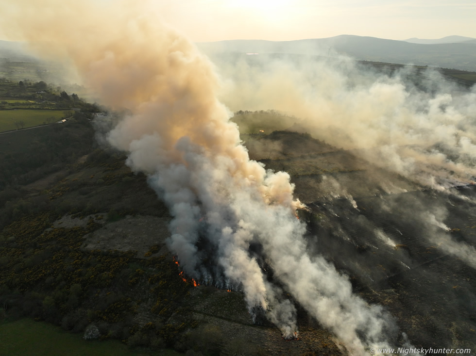
Facing W with orange smoke blowing across the sun
 |
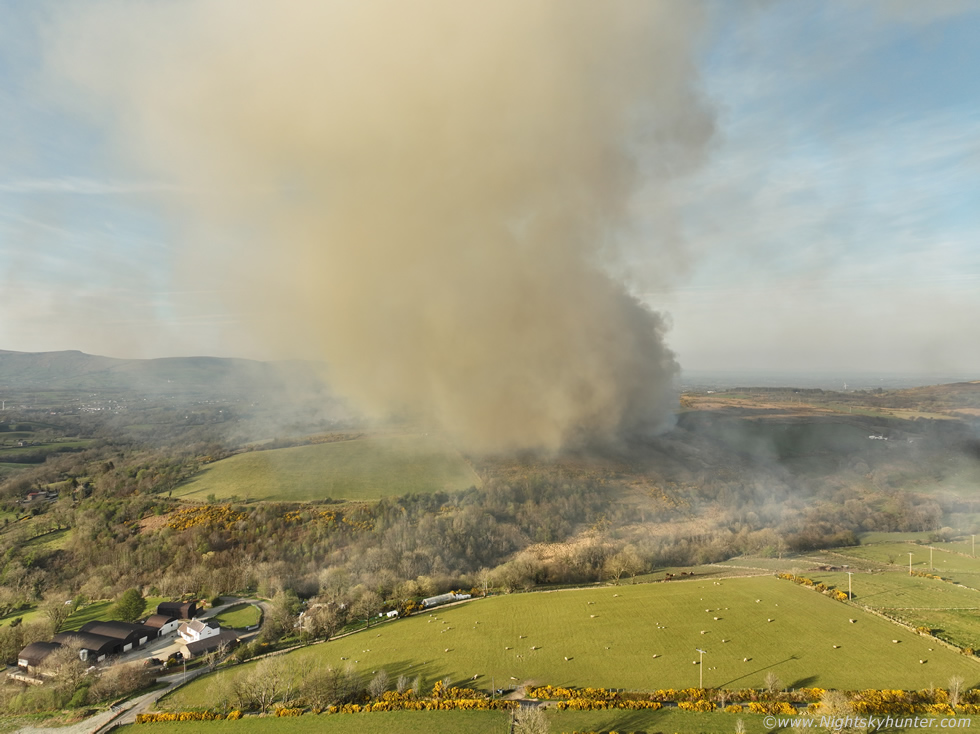
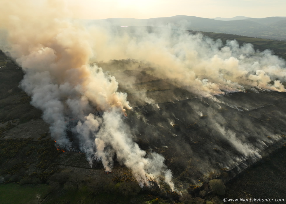
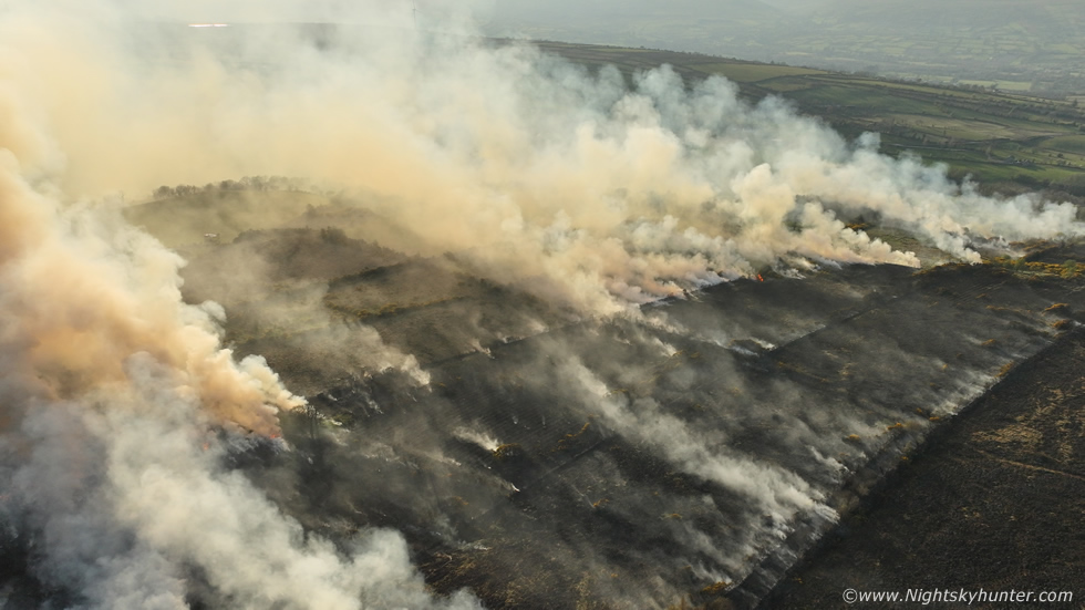
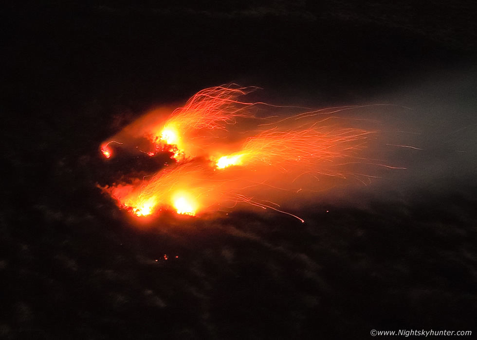
Once I piloted the drone to the rear of the fire I was absolutely astonished, this was massive!, even wider than the Ballygawley fire and with many sources burning in unison. This scene highlights what I mentioned about viewing angles, this looked smaller and more benign from downwind but from the rear its full horror was in plain view, this was a major event and it was unfolding rite now.
 |
Somewhere far below fire fighters were battling the blaze, their figures are too small to make out from this height and scale. Television news reports would later state that crews had to walk four hours across tough terrain and through bushes to get to the fire.
 |
The fire was near the Corrick Road on the Draperstown side of the mountain, people could see it easily from Maghera. Fire appliances from Maghera, Magherafelt, Cookstown & Dungiven were supported by a command unit from Kilrea and specialist wildfire officers tackling the blaze (UTV).
 |
At this moment in time 54 fire fighters were tackling the fire, some of the local farmers had been trying to keep it under control until fire crews arrived but to no avail.
 |
I was still in shock watching this scene through the screen on the controller in real time, I was not expecting to see anything like this today. When you get a view like this it really highlights the kind of work fire fighters have to go through to fight these wild fires. Imagine hiking across bog land and around gorse bushes, up hills, avoiding holes and uneven ground in warm weather carrying gear with a raging fire to fight.
 |
My battery was getting low so I flew back to my vantage point and inserted a brand new battery, this deserved one more flight to document. My DSLR with telephoto lens was laying on the grass beside me but I never used it.
 |
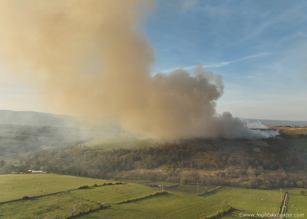
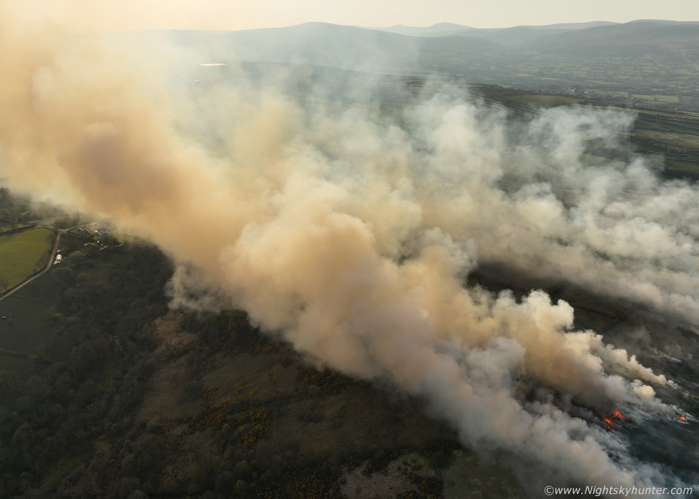
New flight, drone skimming across the countryside to get back to the action, once again approaching from the deceptively small leading edge of the burn downwind from the main area of ignition. The word gorse fire couldn't be anymore fitting, just look at those vibrant gorse bushes with smoke in the sky like some kind of battlefield.
 |
Flying lower to take a look at the flames, still far off the ground here so the flames must have been tall enough in person, I didn't want to risk bringing the drone in too low with this kind of heat rising upward.
 |
Flying in a wrap back around to the area of interest and the view still blew me away, 'Apocalypse Now'. I noticed a very dramatic but sad scene on the far end of the fire to the right hand side of this image, the stark outline of individual trees among the smoke and flames almost waiting to be saved, it was heartbreaking, I flew over for a closer look.
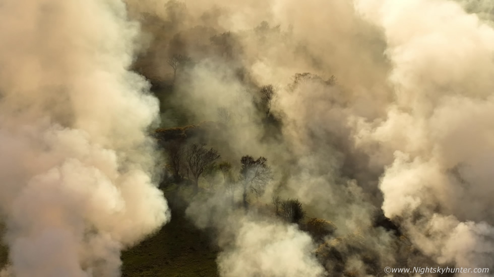 |
Using the digital zoom on the DJI Mavic 3 Classic I was able to get in close without risking the drone and obtained a video sequence of these beautiful trees among the blowing smoke, it was a very haunting scene. Some of the more isolated trees are what I would playfully call 'fairy trees' from the old Irish folklore, the kind of trees I would love to use in my nightscape images with star trails and auroras, it was just so sad to see them in the midst of hell.
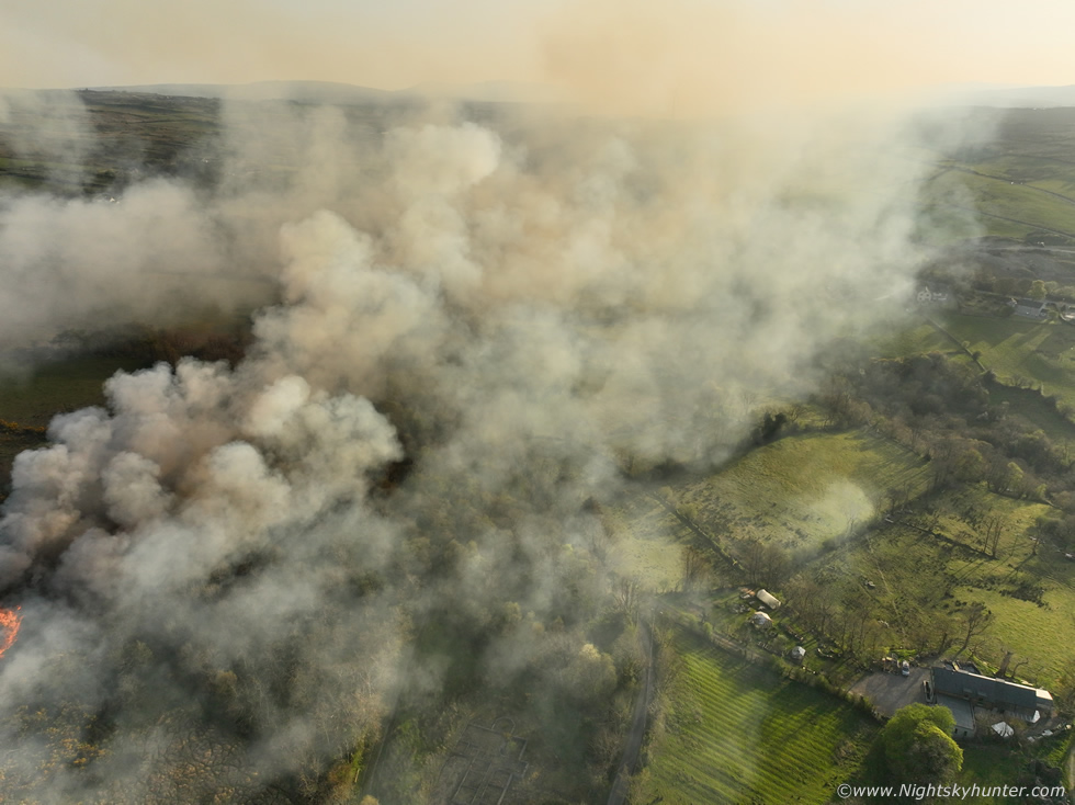 |
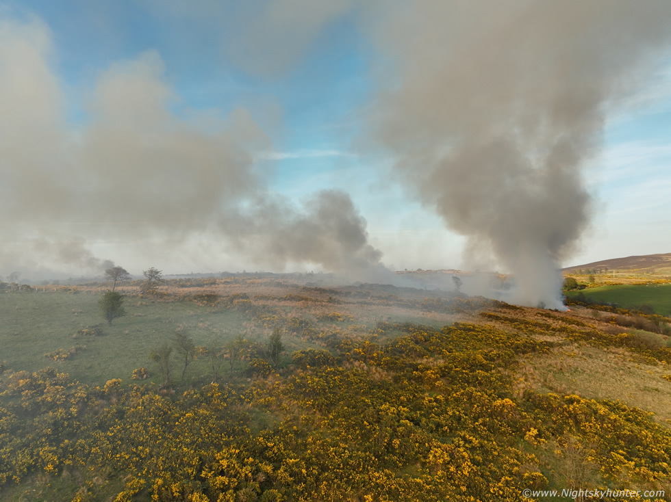
Parting image showing the smoke billowing across the land, lucky house on the right hand side, smoke and flames missing the property. I heard other reports of the fire almost blocking off a narrow lane to someone's house almost leaving them trapped. By the time I landed the drone it dawned on me that I had just witnessed a major fire yet again, with the exception of the Mournes event the Ballygawley and Corrick Road gorse fires were the largest inland fires of the entire week. Soon fire fighters got the best of the blaze and got it under control just in the nick of time, they have been heroes all week!
When I got home and posted my images and footage the media were yet again interested in my content and it was featured in newspapers and BBC and UTV television with reporters going straight to the scene to document the aftermath and widespread damage the following day. Yet again the consensus was that the fire was lit on purpose and many locals were enraged by the incident with some hinting they knew full well who lit the fire, but without evidence nothing could be done about it. The land will take time to recover however the birds and other wildlife would have taken a big knock back and its those species who are the really victims in these fires.
The following night I was getting a little 'burned out' - excuse the pun - from chasing these wild fires so I decided to take the night off and relax at home, I felt certain I had seen the best of it all week. I had a relaxing drink and was going through my footage when images began to appear of a massive fire on Glenshane Pass, I couldn't believe it. This was a night time fire burning for hours with huge flames visible in a long a train of fires among the darkness of the mountain. The fire was located not far from the Ponderosa and was burning along the Maghera side of the mountain. The phone images taken from passing cars posted on social media were spectacular. I reprimanded myself for relaxing so soon, the footage from that fire would have been the grand finale of a very busy week. To be honest I had always wanted to get aerial footage of a wild fire at night so this was a missed opportunity.
The following day the Glenshane fire was on the news, it was still burning but well under control, I decided to let it go, after all, there was a weak front bringing the first showery rain to the Sperrins in over two weeks, no doubt this would put the fire out completely by evening time. Then that night, much to my surprise, the fire was back, and yet again spectacular phone images online showed the massive flames burning across the E side of the mountain which could be seen for miles. This time photographer Colleen Webb was in the area, she had seen the reports to and knew I was keen to capture it so she called to the house and picked me up, together we would get footage of this rare night time fire. We had to wait until midnight before the rain cleared and by the time we got to Glenshane we could barely see it at all, it must have been dying out, in the distance were several small fires marking the last of the big blaze, they where far away and well up the mountain on the Maghera side, they were unreachable from Glenshane even with the drone.
 |
We drove back down the mountain, went through Maghera and made our way to the back roads at the base of Carntogher, our instincts were correct, the fire was up that mountain, we found a break in the trees which lined the narrow country roads to get the drone in the air. We were shocked how windy it was, it was strong and cold. Flying the drone at night is normally a walk in the park for me, I'm well versed in doing so for nine years however this one was a little more tricky and demanded my full attention. Colleen was my spotter and kept an eye on its flashing lights, meanwhile the FPV screen showed a scary scene, by that I mean it showed nothing. Just blackness and above that the moonlit sky which was the only indicator of any orientation, I could see nothing on the mountain to let me know how close I was to hitting it, the only reference were the flames in the darkness which obviously marked the surface, if it wasn't for the fire itself a drone crash into the hills would have been possible unless I flew exceptionally high.
As the drone flew up the mountain the mountain itself climbed in height so I had to constantly adjust altitude to avoid a crash. Plus the fire itself, was it a big fire or a tiny one close to the ground?, I would need to forget about any fancy wraps around the flames with no intel. The wind was so strong and must have been much worse up there, if it wasn't for the great battery life on this drone I wouldn't have even reached the fire at all, but I made it. Short exposure showing the smoke blowing in the wind, look at that image, are those small fires close to the ground or larger flames? it was really impossible to tell in the darkness. Colleen could see the drone's lights above the fire and was able to guide me which helped alot so I recorded some short video clips for the record.
 |
There was something strangely relaxing watching the flames on the screen, they would shrink then swell up in brightness, very hypnotic. The battery percentage would drop from 100% to 34% within ten minutes for a battery that would normally last 30 to 35 minutes during a normal flight, that's how strong the wind was. You can watch this footage on my youtube channel. By the time I landed the drone in the dark road it was after 01.00 in the morning. The moon was bright, some of the stars and planet Jupiter stood out against the sky and I even observed a moonbow, the first I had seen in years. We decided to call it a night, it was a valiant effort, we missed the big show but documented the last of it and it was also a good test for the drone in the dark. With the weather changing back to cooler and unsettled this brought an end to a two week period of wild fires, over the last five days I had documented four of them, two of which were the biggest in years.
Full drone footage of the Lough Fea/Corrick road gorse fire, you might recognize the footage from the news. As I write this now in late April the weather has turned much more unsettled and cooler however there are hints of high pressure returning again. I wonder will this be the end of the wild fires or could there be more to come this Summer?, in the meantime I'm patiently watching the models waiting for thunderstorms and as the clock ticks and the nights grow short I will also be on the hunt for beautiful Noctilucent Clouds. Thanks very much for reading.
Martin McKenna